
Nature-Based Solutions
For a Flood-Resilient Kathmandu
Building Urban Flood Resilience Through Rivers, Streets, Public Spaces and Blue-Green Infrastructure
Valley Constraints and Flood Risk Context
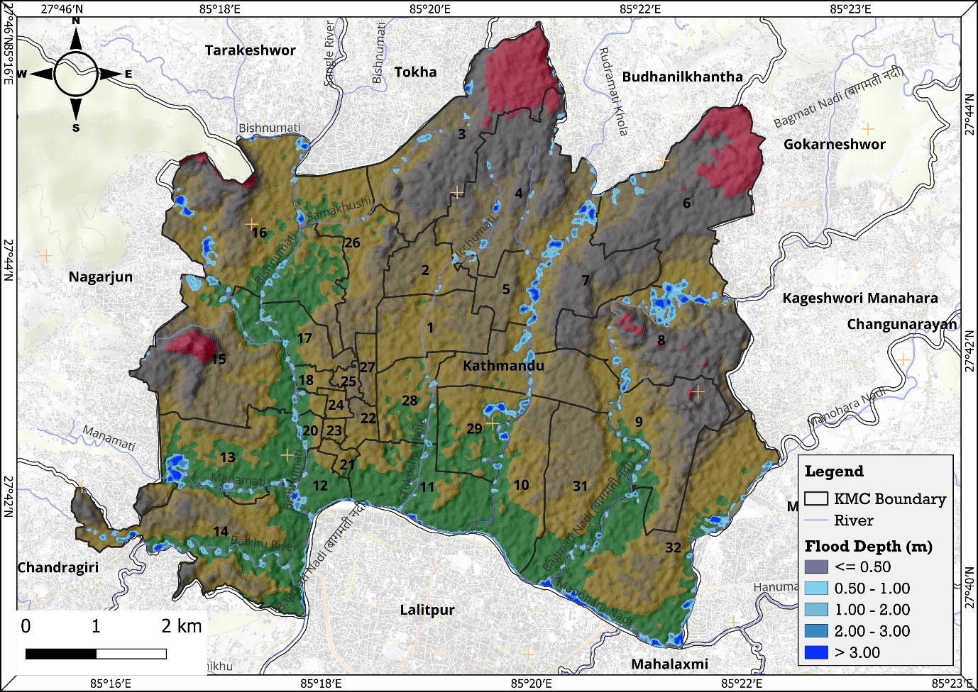
Flood risk in Kathmandu Valley is shaped not only by urban development, but also by changes occurring across the wider watershed. The map highlights areas where upstream landscape conditions, settlement growth and downstream river dynamics interact to influence flood behaviour.

Upstream landscape pressures
Changes in vegetation, slopes and land cover can increase surface runoff, reduce infiltration and accelerate the movement of water towards downstream river systems.
Loss of natural retention
Dams, settlements, land transformation and the decline of natural retention areas alter how rainfall is stored, released and conveyed through the watershed.
Rapid urban exposure
As settlements expand into drainage corridors and low-lying areas, more people, infrastructure and assets are exposed to flood impacts.
River corridors under pressure
Encroachment, constrained channels and infrastructure crossings reduce the capacity of river systems to safely convey high flows during intense rainfall.


Flood risk in Kathmandu Valley is shaped not only by urban development, but also by changes occurring across the wider watershed. The map highlights areas where upstream landscape conditions, settlement growth and downstream river dynamics interact to influence flood behaviour.
Upstream landscape pressures
Changes in vegetation, slopes and land cover can increase surface runoff, reduce infiltration and accelerate the movement of water towards downstream river systems.
Loss of natural retention
Dams, settlements, land transformation and the decline of natural retention areas alter how rainfall is stored, released and conveyed through the watershed.
Rapid urban exposure
As settlements expand into drainage corridors and low-lying areas, more people, infrastructure and assets are exposed to flood impacts.
River corridors under pressure
Encroachment, constrained channels and infrastructure crossings reduce the capacity of river systems to safely convey high flows during intense rainfall.


Kathmandu Valley – Landscape classifications


Kathmandu Valley brings together distinct landscape systems, from mountain slopes and headwaters to foothills, river corridors and the highly developed urban basin.
Different landscapes perform different functions within the valley’s water system.
Understanding these landscape zones helps identify where water can be retained, where natural drainage needs to be protected, and where urban areas can introduce new opportunities for infiltration, storage and safe conveyance.
Flood Risk Hotspots
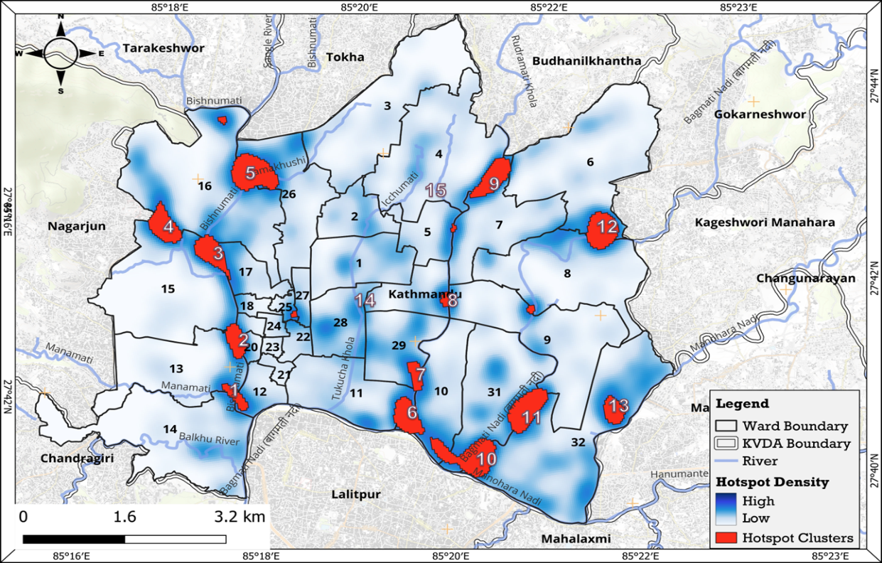
Across KMC, flood risk is not random. 13 flood clusters emerge along the city’s river and drainage network, revealing where water, urbanisation and infrastructure pressures intersect.
A city shaped by water
Bishnumati · Bagmati · Dhobikhola · Manohara
Most clusters trace these river systems and their tributaries — showing how local flooding is connected to the wider urban watershed.
Different places, different pressures
The clusters cut across dense neighbourhoods, markets, major roads, institutional areas, public spaces and culturally important parts of the city. Flooding therefore affects more than property — it can disrupt movement, access, public life and sensitive urban landscapes.
Where risk meets opportunity
Some of the most strategically important locations also contain riverfronts, open spaces and institutional land that can become part of the flood-management system.
The hotspot map is not just a map of where flooding occurs. It is the starting point for asking: what can this place do about water?


Priority Hotspot: Gongabu–Balaju
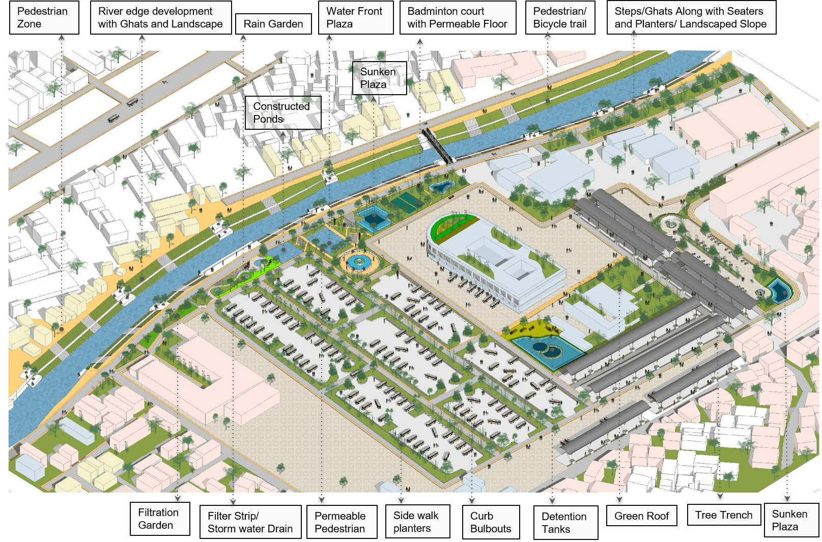
At the scale of the hotspot, flood risk becomes more tangible: the Bishnumati River, Ring Road, Gongabu Bus Park, neighbourhood streets and informal river-edge settlements come together within a highly urbanised landscape.The hotspot reveals a combination of river-edge exposure, drainage constraints, intense movement, impervious surfaces and fragmented open spaces but also a network of places where water-sensitive interventions can be introduced.
What we found
River edge — degraded and constrained sections of the Bishnumati create opportunities for restoration and flood buffering.
Movement corridors — the Ring Road, arterial and local streets generate substantial runoff while offering space for green street and draina ge interventions.
Urban activity — Gongabu Bus Park and surrounding commercial areas concentrate movement and impervious surfaces, making stormwater management particularly important.
Neighbourhood + community spaces — Mhepi Ajima Temple, open spaces and river-edge settlements provide opportunities to combine flood management with public-realm and ecological improvements.
From hotspot to demonstration
Rather than treating the hotspot as one large project, three demonstration sub-sites were selected to test how different parts of the urban system can contribute to flood resilience:
A — Gongabu Bus Park
B — Mhepi–Ajima Temple
C — Ring Road
Together, they demonstrate how transport infrastructure, neighbourhood landscapes and river-connected urban systems can become part of one blue-green network

Flood Dynamics Overview
Hydro-climatic variability dictates that flood risk shifts with rainfall scale. Our interactive tool visualizes how water depth and geographic reach respond to different return-period models.
25-Year Scenario
Historical data for these mid-range events reveals primary vulnerabilities along the Bishnumati banks and adjacent depressions, where confluence points create high-risk overflow zones.
100-Year Scenario
Extreme weather projections show inundation breaching the traditional river limits to engulf large residential blocks and vital transport arteries across the city grid.
Explore the slider <>
Nature-Based Solutions (NBS)


Flood resilience does not have to rely on concrete alone. Nature-Based Solutions work with the landscape to hold, slow, absorb and safely convey water — while creating healthier and more liveable urban spaces.
What can NbS do?
Hold water
Detention landscapes, retention ponds and floodable open spaces temporarily store stormwater.
Slow the flow
Bioswales, rain gardens and vegetated corridors reduce the speed at which runoff reaches drains and rivers.
Let water soak in
Permeable surfaces, infiltration gardens and tree trenches increase infiltration and groundwater recharge.
Restore river systems
Riparian buffers, wetlands and river-edge landscapes improve ecological function while providing additional flood storage.
NbS is a network, not a single intervention
From streets and buildings to parks, public spaces and river corridors, small interventions can work together across the urban landscape.
For Kathmandu, the opportunity is to connect these distributed measures into a blue-green infrastructure network that complements existing drainage and flood-control infrastructure.
Explore the NbS interventions




KMC and KVDA should strengthen the enforcement of rainwater harvesting and groundwater recharge provisions within existing and new developments to reduce runoff generation and enhance localized water retention across the valley.
Integrated site-level stormwater drainage and water management systems should be mandated within new developments to ensure proper runoff capture, conveyance, infiltration, and discharge management.
Avenue plantation and continuous urban green corridors may be promoted along major road networks and river corridors to reduce urban heat, improve ecological connectivity, and support climate-responsive public realm development.
Green roofs, rooftop farming, and vertical greening systems should be encouraged across institutional, commercial, and residential developments to reduce surface runoff, improve thermal performance, and strengthen urban ecological functions.
KMC and KVDA may promote demonstration-based NbS implementation and public awareness initiatives to encourage wider community participation in water-sensitive and climate-responsive urban practices.


NBS Intervention Portfolio
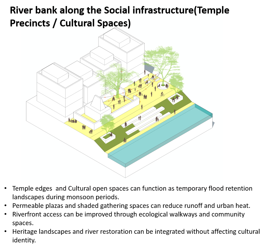
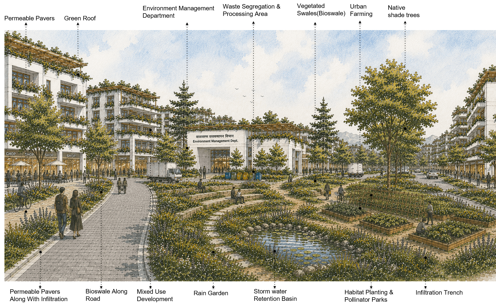
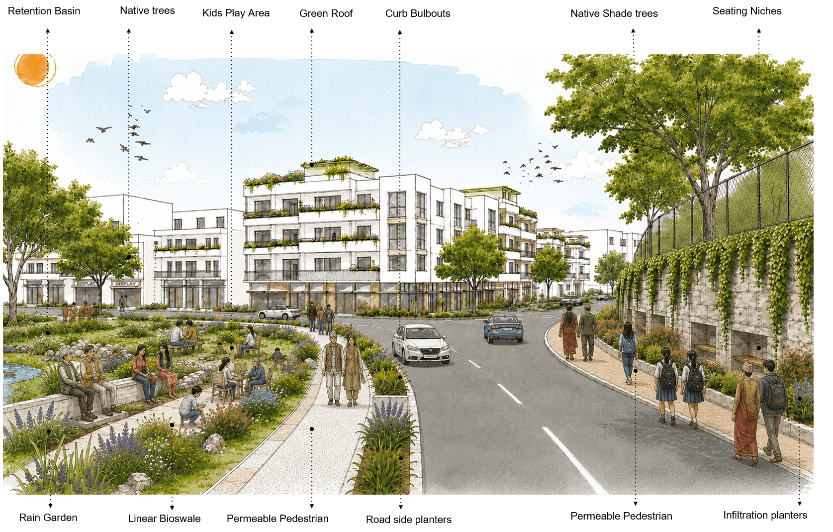
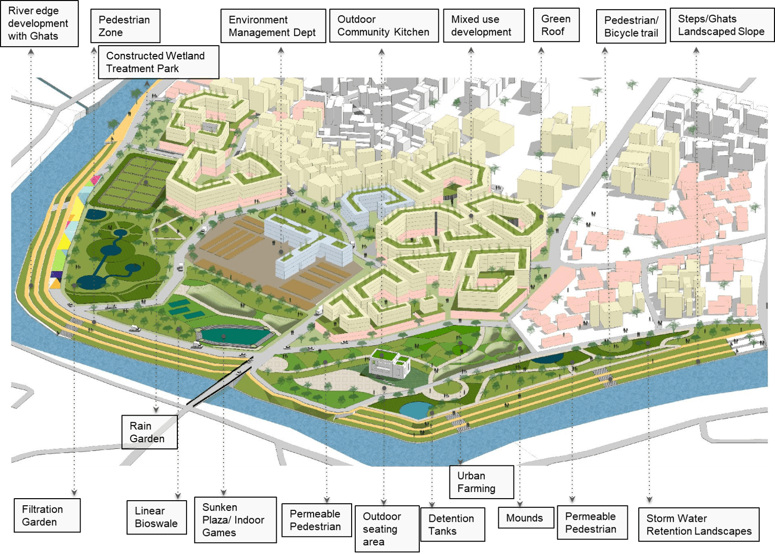
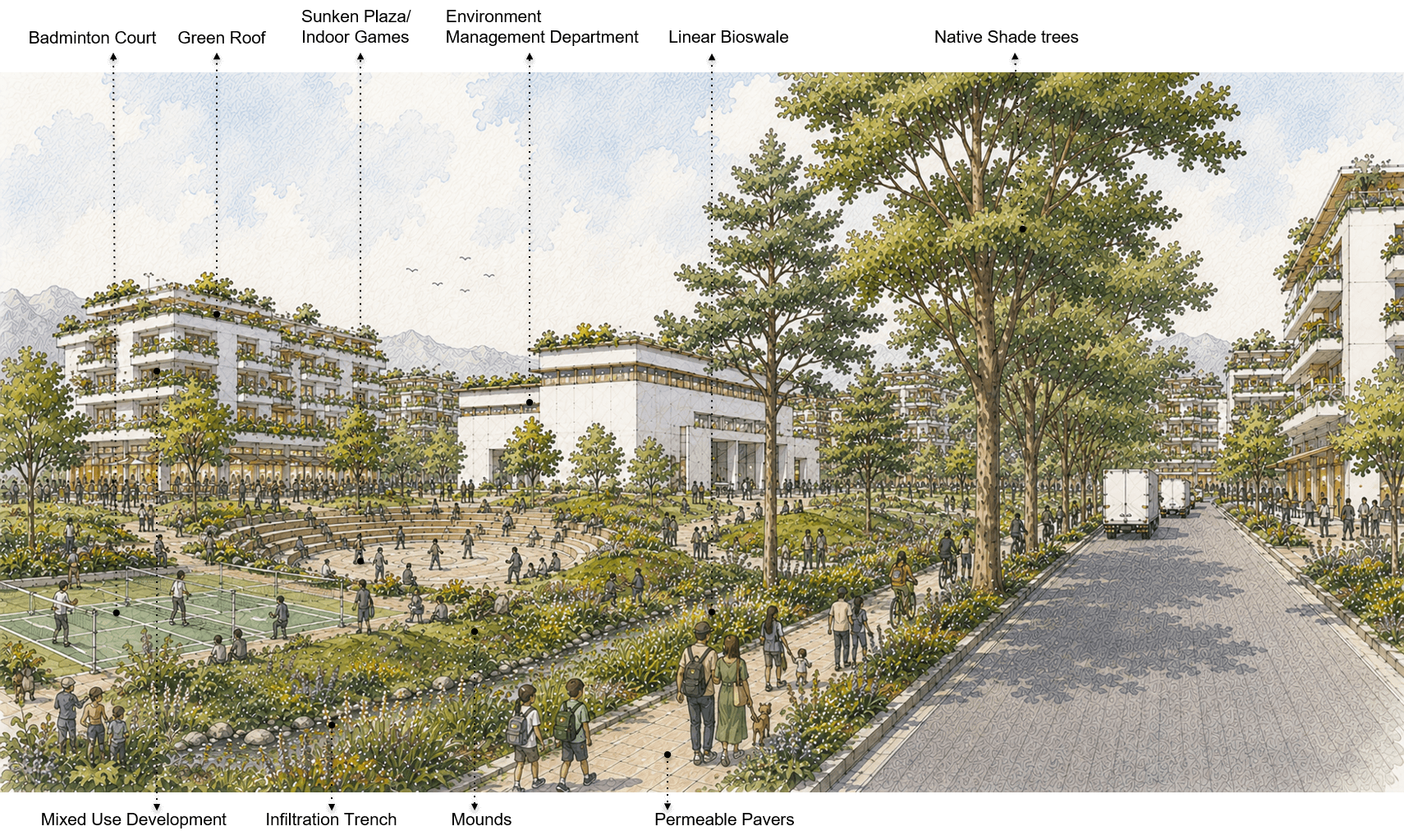
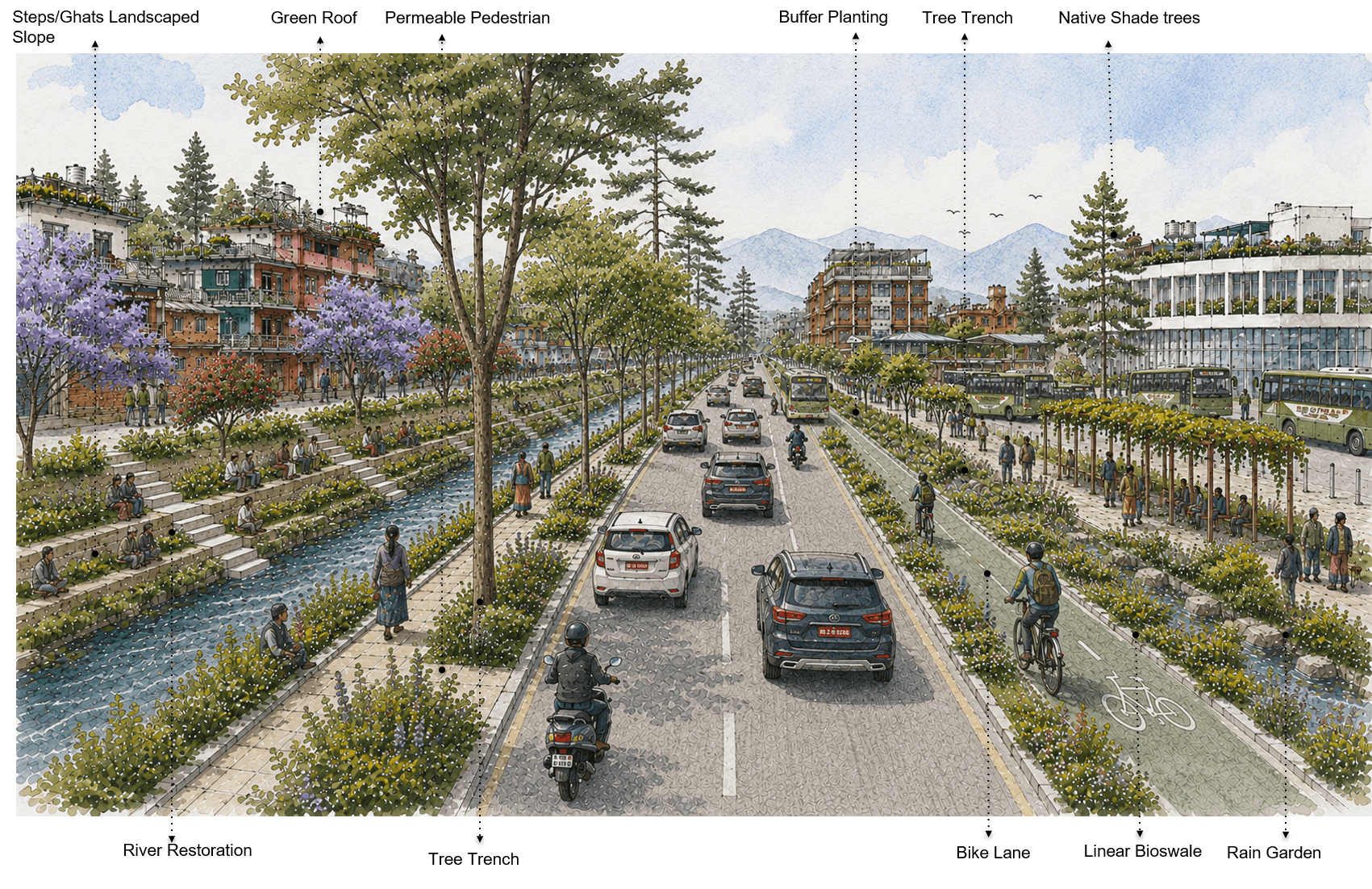
NbS can be integrated across the city as a connected set of small and large interventions—from river edges and public spaces to streets, parking areas and buildings.
The examples shown here demonstrate how everyday urban spaces can be redesigned to capture, slow, filter and retain stormwater, while also improving mobility, public space, ecology and urban comfort.
Explore the interventions



Conclusion
What changes when Nature-Based Solutions are introduced?
The modelling compares flood conditions without NBS against a scenario with 75% implementation of the identified NbS opportunities.
The comparison shows a visible reduction in the extent of deeper flood-affected areas, particularly across river corridors and connected low-lying areas.
No NbS → 75% NbS implementation
The analysis provides a quantitative basis for understanding how distributed interventions across the urban landscape can contribute to reducing flood intensity and improving overall flood resilience.
Use the map slider / toggle to compare the two scenarios.
In conclusion
This platform brings together the key findings, spatial analysis and Nature-based Solutions (NbS) opportunities developed through the study on flood resilience and NbS for Kathmandu Metropolitan City (KMC).
The assessment demonstrates that flood resilience in Kathmandu cannot be addressed through isolated interventions alone. It requires a connected approach across river corridors, drainage networks, streets, open spaces, cultural landscapes and the built environment. The proposed NbS framework and site concepts provide a basis for identifying where interventions can be integrated into the existing urban system.
The hotspot assessment, flood modelling and before–after NbS scenarios help illustrate how nature-based interventions can contribute to reducing flood impacts, while the institutional and implementation analysis provides a pathway for moving from opportunities towards action.
The site concepts presented on this platform are intended to support discussion, prioritisation and further development. Detailed implementation will require site-specific surveys, technical feasibility assessment, stakeholder coordination and appropriate design and engineering studies.
From Analysis to Action
Stakeholder Validation Workshop
The proposed flood-risk findings, NbS opportunities and intervention concepts were presented to stakeholders for review and discussion.
• The workshop provided an opportunity to:
• Validate identified flood hotspots and priority areas
• Review proposed NbS opportunities
• Discuss institutional roles and implementation pathways
• Identify practical considerations for implementation
• Gather stakeholder inputs to refine the proposed interventions


Contact
Access comprehensive documentation, interactive tools, and research data to support your flood resilience and nature-based solutions projects in the Kathmandu Valley.